
The government declared Monday (Dec 4) a public holiday and urged private companies to encourage 'work from home' option for its employees in Chennai, Tiruvallur, Kancheepuram and Chengalpattu districts.

The IMD has warned of squally winds speed reaching 45-55 kmph gusting to 65 kmph likely to commence along and off Odisha and north coastal Andhra Pradesh coasts from October 27 onwards.

As Cyclone Dana barrels toward the coasts of Odisha, threatening to impact nearly half of the state's population, the government is racing against time to execute a massive evacuation plan aimed at relocating about 10 lakh people in several coastal districts to safety. In West Bengal, the cyclone is set to bring heavy rainfall in several southern West Bengal districts, including Kolkata, the India Meteorological Department (IMD) has said.

The West Bengal government has taken all precautionary measures to deal with Cyclone Yaas, likely to hit the state on May 26, and Chief Minister Mamata Banerjee will stay at a control room set up for the purpose to monitor the situation, officials said.

The system is likely to move in a northerly direction and cross the Andhra coast between Bapatla and Kakinada.

The Met Department has predicted light to moderate rainfall across parts of West Bengal, Andhra Pradesh and Odisha with the probability of the severe cyclonic storm 'Asani' recurving.
As many as 57 villages were marooned and 60 mandals were affected. As many as 33,570 families were affected out of whom 9,257 families were evacuated and lodged in 31 relief camps.
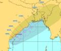
The strong wind that is expected may cause damage to thatched houses, uproot trees and disrupt power supply and communication network in coastal Orissa and neighbouring AP.

The storm would continue to move north-northwestwards, intensify further and reach north Bay of Bengal near West Bengal and the adjoining north Odisha and Bangladesh coasts by the morning of May 26

India recorded around 16 per cent more rainfall than normal in August, with rainfall over Northwest India recorded at 253.9 mm, the second highest in August since 2001, the India Meteorological Department (IMD) said on Saturday.

This would be the second cyclonic storm in the Arabian Sea this year.

After its late withdrawal from northwest India, the southwest monsoon remains active over some parts of the country.
Heavy rainfall coupled with gusty surface wind is likely to pound some parts of Odisha as the deep depression over west-central Bay of Bengal intensified into a cyclonic storm 'ROANU' on Thursday.

The southwest monsoon is set to make its exit in style, bringing rains to the parched parts of Uttar Pradesh and Bihar, as weather forecasters have picked up signs of formation of a cyclonic circulation over Bay of Bengal. Addressing a press conference in New Delhi, India Meteorological Department (IMD) director general Mrutyunjay Mohapatra on Thursday junked last week's forecast of early withdrawal of southwest monsoon and announced the extended stay of the seasonal showers. "Even though we expected early withdrawal of the southwest monsoon, a cyclonic circulation over west-central and adjoining northwest Bay of Bengal will shift the monsoon trough southwards around September 7.

Spurred by cyclone Remal, the southwest monsoon set in over the Kerala coast and parts of the northeast on Thursday, a day earlier than forecast by the weather office.

Earlier on Tuesday, Odisha Special Relief Commissioner Pradeep Kumar Jena said that cyclone Asani is likely to reach Kakinada on the Andhra coast on Wednesday morning.

It's still early days, but the southwest monsoon has been nearly 37 per cent 'below normal' in the first seven days (June 1-7) of this month. According to the data furnished by the India Meteorological Department (IMD), between June 1 and June 7, India received 14.5 millimetres (mm) of rainfall, against a 'normal' 23.1 mm. Among places where rains have arrived, monsoon in Kerala in the first seven days has been 48 per cent 'below normal', while in Puducherry, it has been 56 per cent 'above normal'. In Tamil Nadu, rains were 21 per cent 'above normal' between June 1 and June 7.

Addressing a press conference virtually, India Meteorological Department Director General Mrutyunjay Mohapatra said September was likely to witness normal rainfall in the range of 91-109 per cent of the long period average of 167.9 mm.

Andhra Pradesh Chief Minister N Chandrababu Naidu and his Telangana counterpart Revanth Reddy visited some inundated areas in their respective territories.

'There's also a possibility of the cyclonic system changing its course, thus avoiding a landfall in Odisha'
The depression, which was initially over west-central Bay of Bengal and adjoining areas, moved westward and intensified into a deep depression.

The low-pressure area over the South Andaman Sea and adjoining southeast Bay of Bengal is very likely to move northwestwards and intensify into a depression by Saturday, the weather office said.

Prime Minister Narendra Modi on Friday reviewed the post-cyclone situation and damages caused by Cyclone Yaas in the state at a meeting in Bhubaneswar where Odisha government demanded long term solutions to mitigate problems of repeated cyclones and provision of disaster resilient power systems.

The weather system over the South Andaman Sea and the adjoining southeast Bay of Bengal is very likely to move north-westwards and strengthen into a depression by Saturday, the Met Department said.

The slow progress of the south-west monsoon has led to overall deficiency of rains by 22 per cent over the last fortnight, the meteorological department on Wednesday said.

The rains after arriving over Kerala will quickly cover Tamil Nadu and Karnataka, but then might slacken a bit, which could delay its arrival over Northwest India.

The India Meteorological Department said rainfall would be accompanied by gale wind speed reaching 140 to 150 kmph and gusting to 165 kmph along and off Odisha and north Andhra Pradesh coasts.

Severe cyclonic storm Michaung crossed south Andhra Pradesh coast close to Bapatla district between 12.30 pm and 2.30 pm on Tuesday with maximum gales of up to 90-100 km per hour speed, said an Amaravati Meteorological Centre official.

It will also be the third cyclone to hit the western state in June since 1965, the meteorological office said.

The IMD has also issued a red-coded warning alert to the Odisha and West Bengal coasts.

The cyclone expected to weaken gradually over the next two days.

Cyclonic storm Yaas is very likely to make landfall near Balasore in north Odisha with a speed of 155 kmph to 165 kmph, gusting to 185 kmph, around noon on May 26, the Met department said.

'Usually the average rainfall per day is around 8 mm and India is receiving 10 to 11 mm per day since the last one week.' 'July seems to be very good for the entire country.'
The IMD, in its onset date forecast on May 15, had said the monsoon is likely to hit the southern state on June 5, four days after its normal arrival.

While man and a woman were reported killed when trees came crashing down on them in North 24 Parganas district of West Bengal, a 13-year-old girl died in a similar incident in adjoining Howrah. No casualties have been reported from Odisha yet.

Heavy to very heavy rains are expected in Maharashtra, Gujarat, west Madhya Pradesh and Goa in the next couple of days, the India Meteorological Department said.

A purported video of the incident showing the mob beating the women up mercilessly on Wednesday was shared in the social media by Amit Malviya, the head of BJP's IT cell on Saturday.

The El Nino impact on the Indian monsoon typically manifests by way of extended break in rainfall.

The central and western parts of India, which form the core monsoon zone, may face challenges in coping with the drying effects due to inadequate rainfall early in the season, Skymet Weather said.